Classes for Working with Geo-Data
There are several classes that provide the following functions for working with geography data (geo-data):
- Setting a coordinate system (creating a geo-data entity).
- Updating a coordinate system.
- Creating a geo-map entity.
- Saving a geo-map into a drawing database.
- Changing the geo-map type and resolution, etc.
The following picture demonstrates a diagram with Geo-related classes.
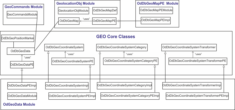
This class diagram consists of core Geo-related classes and the classes of four Geo-related modules.
The main Geo-related class is OdDbGeoData. This class defines an active
coordinate system (CS) and other global database Geo-related properties. It
provides functions for adding a geolocation marker (one per drawing) and a background
map to a drawing.
Note: A geolocation marker is drawn on each viewport if the
GEOMARKERVISIBILITY system variable is set to 1.
To get the OdDbGeoData object ID, use the global oddbGetGeoDataObjId() method.
The OdDbGeoPositionMarker class represents a marker at a position with comments
(not the same as a geolocation marker which is one per drawing; geoposition
markers can be multiple per drawing). Geoposition markers can be moved around
a geo-map.
OdDbGeoCoordinateSystem is an abstract class that represents a coordinate reference system
(CRS) definition.
OdDbGeoCoordinateSystemCategory is an abstract class used for representing
a category which holds string identifiers referring to a group of coordinate
reference systems.
OdDbGeoCoordinateSystemTransformer is an abstract class that represents a transformer
object which is used to transform points from the source CRS to the target CRS.
Protocol Extensions
For working with abstract classes, there is a set of protocol extension classes:
OdDbGeoDataPEis an abstract class for geo-data needs. Sample implementation is in theOdGeoDatamodule.OdDbGeoCoordinateSystemCategoryPEis an abstract class that contains interfaces of virtual methods used for creating coordinate system categories. Sample implementation is in theOdGeoDatamodule in theOdDbGeoCoordinateSystemCategoryPEImplclass.OdDbGeoCoordinateSystemPEis an abstract class that contains interfaces of virtual methods used for creating objects that are anOdDbGeoCoordinateSystemclass's inheritors. Sample implementation is in theOdGeoDatamodule in theOdDbGeoCoordinateSystemPeImplclass.OdDbGeoCoordinateSystemTransformerPEis an abstract class that represents a protocol extension for a transformer object used to transform points from the source coordinate reference system to the target coordinate reference system. Sample implementation is in theOdGeoDatamodule.OdDbGeoMapPEis a class for geo-map needs. Sample implementation is in theOdDbGeoMapPEmodule.
Modules for Working with Geo-Data
The following modules demonstrate how to work with geo-data.
OdGeoData Module
OdGeoData module implements OdDbGeoCoordinateSystemCategoryPE,
OdDbGeoCoordinateSystemPE, OdDbGeoCoordinateSystemTransformerPE,
and OdDbGeoDataPE classes and is located in Drawing/Extensions/OdGeoData. This
module uses csmap and tinyxml libraries.
GeolocationObj Module
GeolocationObj module provides the following functions for
working with geo-maps:
- Creating geo-map objects and adding them to a database.
- Rendering a drawing that contains geo-map objects.
- Changing geo-map object properties.
GeolocationObj module is located in Drawing/Examples/GeolocationObj and consists of several classes:
OdDbGeoMap— A piece of the global map (as an image).OdDbGeoMapDef—OdDbGeoMapobject definition.OdDbGeoMapPE— Protocol extensions for working with geo-map objects.OdDbGeoMapFieldsPE— Set/get methods forOdDbGeoMapobject properties. This class is used in classes that inherit theOdDbGeoMapPEclass.
GeolocationObj module implements all OdDbGeoMap methods except the updateMapImage() method because it depends on whether the OdDbGeoMapPE module is loaded.
OdDbGeoMapPE Module
OdDbGeoMapPE module implements the OdDbGeoMapPE class
functionality. It is located in Drawing/Examples/OdDbGeoMapPE.
The main purpose of the OdDbGeoMapPE module is implementing the updateMapImage()
method for updating geo-map objects.
OdDbGeoMapPE module uses curl and tinyxml third-party libraries. The curl library
is used for getting map images from the Internet (uses BING online service).
To access the BING service, set your own BING-map key as a value of the sBingMapsKey
global variable.
Note: The geo-data protocol extension object should be loaded for the OdDbGeoMapPE module work.
GeoCommands Module
GeoCommands module implements commands for working with geo-data listed below:
Geocommand creates geo-data by specified coordinate system.GeoRemovecommand removes geo-data from file.GeoReorientMarkercommand reorients geo-data marker.GeoMapcommand changes the geo-map type for the current viewport (defined byGEOMAPvariable).GeoMapImagecommand creates the geo-map.GeoMapImageSetMapTypecommand changes the geo-map type of the created geo-map.GeoMapImageSetResolutioncommand changes the geo-map resolution.GeoMapImageUpdatecommand updates the geo-map.
The GeoCommands module is located in Drawing/Examples/GeoCommands.
Third-Party Libraries for Working with Geo-Data
The third-party libraries, used in the OdGeoData and OdDbGeoMapPE modules, are located in the ThirdParty folder:
- The
csmaplibrary implements coordinate system support and calculations. - The
curllibrary implements geo-map image updating. - The
tinyxmllibrary is used for working with .xml-files.
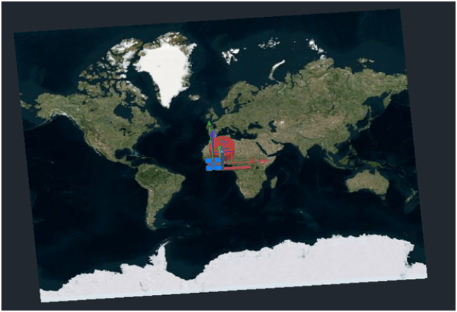
A drawing that represents the results of GeolocationObj, OdGeoData, and OdDbGeoMapPE
modules is below.

The background map comes from geo-data (geo-data drawing not implemented yet).
The white border map is the OdDbGeoMap object. The red marker is a geolocation marker.
The yellow marker is a geo-position marker.
Coordinate System Dictionaries
The csmap library should have access to a folder with
the required dictionaries. The dictionaries are available for downloading from https://www.opendesign.com/odoutgoing/LatestRelease/. The dictionaries from the most recent release work with any Drawings SDK version.
To download and set up the dictionaries, follow the steps below:
- Navigate to the most recent release folder in the ODA Downloads area: https://www.opendesign.com/odoutgoing/LatestRelease/.
- Open the
Thirdpartyfolder and downloadCSDicts_<release_version>.ziparchive. - Unzip the archive.
- Set the
MENTOR_DICTIONARY_PATHorCS_MAP_DIRenvironment variables pointing to theCSDictsfolder. On Windows, you can alternatively create the CSDicts folder in the application directory (for example,exe\vc9dlldbg\CSDicts) and copy the dictionary files to it. - If you want to use user dictionaries, set the
MENTOR_USER_DICTIONARY_PATHvariable pointing to the user dictionary directory. On Windows, you can alternatively create theCSUserDictsfolder in the application directory (for example,exe\vc9dlldbg\CSUserDicts).
For ODA members who have access to the Drawings Git repository, the dictionary files are also available in the main/ThirdParty/csmap/Dictionaries directory.
Sample code of working with geo-data
Sample code that illustrates how to work with geo-data can be found in:
DbFiller::addGeoStuff()method of theOdWriteExexampleGeoMarkPositioncommand in theExCommandsmodule.